


MarineTraffic - Ship Tracking
2.94.30K Reviews
App Specs
- Version
- 5.8.3
- Updated On
- License
- Free
- Downloads
- 10,000,000+
- Developer
- MarineTraffic Applications
- Categories
- Maps & Navigation
- Platform
- Android, iOS
Screenshots
 Analysis by AppCompare
When I stand near a harbor, I often find myself wondering what the vessels moving across the water are doing and where they are going. MarineTraffic - Ship Tracking turns that curiosity into something I can explore on a map, and it can also help people who follow particular ships for practical reasons. The important question is not just whether there is a lot to look at, but whether the information is comfortable to read and useful in the situations where you need it.
Readability on a busy map
The central view is a map filled with moving vessels, so the experience depends on how well you can make sense of a visually busy area. I find it most useful to begin with a broad view, then zoom toward a harbor or stretch of coast rather than trying to interpret every marker at once. That simple habit makes the display feel less crowded and helps me focus on the ships relevant to my question.
MarineTraffic Applications develops this free Maps & Navigation app. It has a 4.7 average from around 123,000 ratings, and more than 5 million installs. The scale of that audience is reassuring, though popularity alone does not tell me whether a map will suit everyone. I would treat it as a visual reference first and take time to learn which details matter to my own use.
The World at Your Fingertips
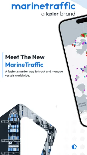
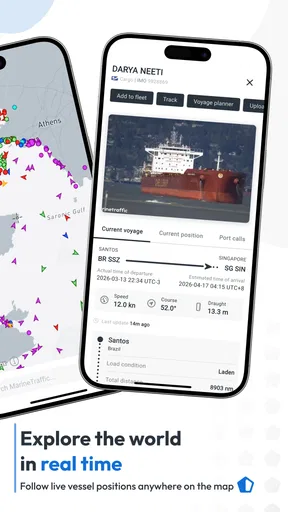
So, what’s the deal with MarineTraffic? In a nutshell, it allows you to track ships in real-time, all around the globe. Using AIS (Automatic Identification System) data, the app provides detailed information about ship locations, routes, and even specifics like speed and destination. It’s like having a personal maritime radar right in your pocket!
Diving Into the Features
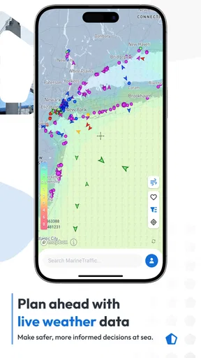
Let's navigate through some of the standout features. The app boasts an interactive map that’s not only easy on the eyes but incredibly informative. You can zoom in on particular areas or follow a specific vessel. The map is updated in real-time, so you’re always in the loop.
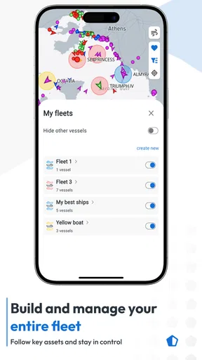
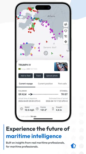
One feature I really dig is the "My Fleet" option. You can create and customize a list of ships you want to keep an eye on. Whether it’s for business or pleasure, having a personalized fleet helps you stay organized.
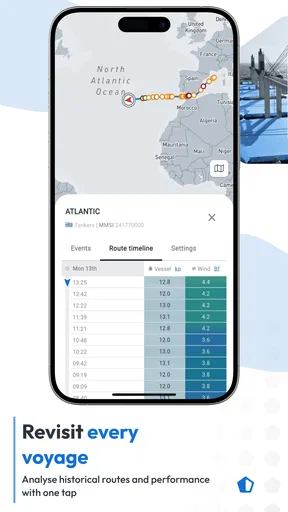
Oh, and if you’re all about stats, you’ll love the detailed vessel information. From ship dimensions to cargo details, the app spills the beans on everything you might want to know. Plus, it offers historical data, which is great if you want to track a ship’s past journeys.
Worth Reading Before You Choose

EA SPORTS FC Mobile 26 Is a Bigger Football Game, but It Takes Time

Flipboard Shows What News Apps Must Do Beyond the Feed

Switching to Android Auto Means Rethinking Your Driving Routine

Google Calendar Makes a Crowded Week Easier to Manage

Ludo King Makes the Most of the Minutes Between Plans

Baby Panda World Brings Quick Play to Modern Phones, but Its Game Library Feels Busy
A quieter way to explore vessels
For me, the best use of a personal fleet is not simply collecting interesting ships; it is reducing repeated searches. If I follow a ferry, a cruise vessel, or a cargo ship I care about, keeping it in one place gives me a quick starting point the next time I open the map. I would build the list gradually and remove vessels that are no longer relevant, rather than turning it into a long archive that takes effort to scan.
Historical journeys are useful for a different reason. When a vessel’s current position looks surprising, a past route can give context: it may be part of a regular pattern rather than an unusual detour. I would use that history to understand what I am seeing, not as proof of a future arrival time. A tracking map is a way to follow reported movement, not a guarantee that a ship will keep to a timetable.
That distinction matters for practical use. Someone waiting for a delivery can check the vessel’s progress and get a broad sense of where it is, but I would not make a time-sensitive plan from the map alone. Port operations, route changes, and the interval before a position appears can all affect what a viewer sees. For a casual observer, this is an interesting detail; for a business decision, it is a reason to treat the app as one useful reference rather than the only source of truth.
Ease of Use
Now, the user interface—let’s talk about that. It’s clean, intuitive, and doesn’t require a degree in navigation to figure out. Even if you’re not tech-savvy, you’ll find your way around easily. The app runs smoothly, although occasionally, it might take a moment to load, especially if you’re tracking a busy area.
The app also offers notifications and alerts. You can get pinged when a ship arrives at its destination or whenever there's a significant change. It’s super handy if you’re tracking a shipment or just curious about a vessel’s journey.
Motor, sensory, and situational access
Touching and zooming a map takes more precision than reading a simple list. If small map symbols or dense clusters are uncomfortable for your eyes, I would start at a wider zoom and open individual vessel details only when needed. That creates a calmer sequence: scan the region, choose one ship, read its information, then return to the overview. It is less tiring than repeatedly pinching and panning across a crowded port.
For users who find frequent gestures difficult, the practical trade-off is that the map is the heart of the experience. My Fleet and alerts can reduce the amount of searching and navigation, but they do not turn vessel tracking into a completely hands-free or text-only task. I would set up the ships I care about when I have time and use alerts to avoid checking the map every few minutes. That approach can also help anyone who prefers fewer interruptions while working or traveling.
The app is most comfortable when you can give it focused attention and a steady connection. In a noisy or crowded setting, checking a ship’s details may be harder than looking at a simple status notification. If you are standing on a pier, walking beside traffic, or supervising children, I would wait until you are safely stopped before exploring the map. It is an engaging way to identify vessels, but it is not something I would recommend navigating while distracted.
When it fits—and when another tool is better
Compared with a general navigation app, MarineTraffic is aimed at vessels rather than helping you drive, walk, or find a road route. A standard map is usually the better choice if your immediate task is getting across town or locating a nearby business. MarineTraffic makes more sense when your question is specifically maritime: which ship is approaching, what vessel is offshore, or where a ship has been traveling.
It also differs from simply watching the water and trying to identify ships by sight. The app can add names, routes, and vessel details to that view, which is particularly useful at a busy harbor where several ships may be visible at once. On the other hand, if you only want a quick answer about one passenger sailing, a direct update from the transport operator may be more suitable for planning. I would use this app to follow the vessel and use the operator’s own information for decisions that depend on exact service arrangements.
A realistic everyday example is a family member waiting for someone arriving by cruise ship. I would save the vessel in My Fleet, check its position when convenient, and use an arrival alert as a prompt to look again. I would not leave for the terminal based solely on a marker appearing close to shore. The app helps make the journey visible, while local arrangements and the ship’s actual arrival process still determine when it is sensible to travel.
Sailing Through the Options
MarineTraffic offers both a free and a premium version. The free version is pretty robust, but if you’re looking for more detailed insights and fewer ads, the premium option might be worth considering. It opens up additional features like weather maps and advanced search filters.
The app is free to download, with optional in-app purchases ranging from less than a dollar to just under a hundred dollars per item. I would explore the free experience before paying, then decide whether a particular extra solves a real need. Someone who checks a ship now and then may not get much value from advanced filters, while a frequent follower who searches across many vessels may appreciate the added control. The age rating is Everyone, so the subject matter is broadly suitable, though the amount of map detail may still feel like too much for a young or easily overwhelmed user.
There’s also a community aspect to the app. You can share photos and information with other users, which adds a social element to the experience. It’s like Instagram for ship enthusiasts!
That sharing side is a nice extra for people who enjoy photographing vessels or comparing observations, but I would not treat community posts as the same thing as position information on the map. Keeping those purposes separate makes the app easier to use: consult tracking for movement, and browse shared material when you want the enthusiast perspective. If social features are not your thing, the ship map and saved fleet still give the app a clear purpose.
What to expect from tracking
A common question is whether a displayed vessel position should be read as an exact, live account of what is happening at sea. I would read it as tracking information that can help orient you, not as a promise of uninterrupted, second-by-second visibility. A ship may not appear in the way a new user expects, and a busy area can take longer to load, so it is sensible to allow a little time and check again rather than assume that a missing or unchanged marker tells the whole story.
Another practical question is whether I need a professional reason to use the app. Not at all: watching ships from a beach, learning the names of vessels in a harbor, or following a cruise can all be satisfying reasons. The difference is how much detail you want. If a moving map and vessel records sound fun, there is plenty to explore; if you only need a simple answer once, a general search or a transport provider’s own update may involve less effort.
The current version is 5.0.6 and supports devices running Android 9 or later. That makes the operating-system requirement worth checking before installing, especially on an older phone. The app first appeared on December 18, 2012, and its long presence in the category suggests a well-established product, but I would still judge it by how it behaves on my own device and in the places where I plan to use it.
Wrapping it Up
In conclusion, MarineTraffic - Ship Tracking is a fantastic tool for anyone fascinated by the maritime world. Whether you're tracking a loved one's cruise, keeping tabs on commercial shipping, or just curious about the vast oceanic highways, this app is your go-to. It’s informative, user-friendly, and offers a global view of maritime traffic that’s hard to beat.
My recommendation is strongest for curious observers, ship enthusiasts, and people who regularly need a vessel-focused map. I would hesitate to recommend it as the only tool for professional timing decisions, or to someone who finds dense maps difficult to navigate and only wants a quick, simple status. Used at a comfortable pace—with a small saved fleet, selective alerts, and realistic expectations about what a tracking display can tell you—it is a rewarding way to understand the movement on the water.
So, if you’re ready to embark on this digital maritime journey, head over to your app store and give it a whirl. Fair winds and happy tracking!
Pros
- Real-time ship tracking worldwide.
- User-friendly interface with intuitive maps.
- Detailed vessel information available.
- Customizable alerts for specific ships.
- Historical data tracking for analysis.
Cons
- Requires a stable internet connection.
- Some features need a premium subscription.
- Occasional delays in data updates.
- Limited offline functionality.
- Battery usage can be high on mobile.
FAQs for MarineTraffic - Ship Tracking
What is MarineTraffic and how does it work?
MarineTraffic is a comprehensive ship tracking app that allows users to monitor vessel movements in real-time. It utilizes a network of land-based AIS receivers to capture and display live ship positions on a global map. Users can track specific ships, view port activity, and access detailed vessel information, making it essential for maritime enthusiasts and professionals.
Is MarineTraffic free to use, or does it require a subscription?
MarineTraffic offers both free and paid versions. The free version provides basic ship tracking features and limited access to vessel details. For more advanced features such as unlimited vessel tracking, historical data, and extended map layers, users can opt for a subscription plan, which is available at various pricing tiers to suit different needs.
What platforms is MarineTraffic available on?
MarineTraffic is available on multiple platforms, ensuring accessibility to a wide range of users. It can be downloaded on Android and iOS devices via the Google Play Store and Apple App Store, respectively. Additionally, users can access MarineTraffic through its web-based platform, which offers similar functionalities as the mobile applications.
How accurate is the ship tracking information on MarineTraffic?
The accuracy of MarineTraffic's ship tracking data depends largely on its expansive network of AIS receivers. While it provides reliable and up-to-date information, factors like signal reception, ship transponder capability, and environmental conditions may occasionally affect data accuracy. However, MarineTraffic is generally regarded as one of the most accurate ship tracking services available.
Can MarineTraffic be used for professional maritime operations?
Yes, MarineTraffic is widely used by maritime professionals including shipping companies, port authorities, and logistics managers. Its comprehensive tracking and data analysis features support various operational needs. However, for critical operations, it is recommended to use MarineTraffic in conjunction with official maritime navigation systems to ensure safety and compliance.


